Spatial
Advertisement
Java Spatial Index (RTree) Library v.1.0b8
The Java RTree project aims to maintain an Java version of the RTree spatial indexing algorithm.
Advertisement
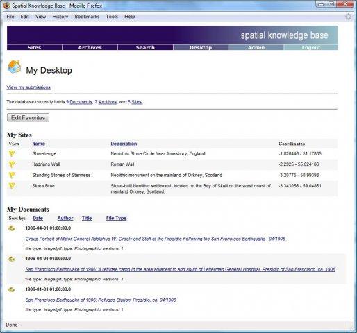
Spatial Knowledge Base v.2.1.3
Spatial Knowledge Base is a web based application for storing and searching of archaeological sites information.
CHIP Spatial/Temporal Cluster Generator v.1.0
The CHIP Cluster Generator attempts to create spatio-temporal cluster data in an automated fashion to help evaluate epidemic detection software.
DualCAD Spatial v.1.0
The DualCAD project is an ongoing project 'over 17 years' to create a freeware cad application that handles the basic needs of most microstation users.
SADA v.4. 1. 1950
Spatial Analysis and Decision Assistance (SADA) is free software that incorporates tools from environmental assessment fields into an effective problem solving environment.
Speleoliti v.3.0
Speleoliti is a powerful and user-friendly software for spatial modelling. It is especially designed for speleological needs (cave mapping software), but also suitable for other kind of geo-works.
Merry Motors v.2.5.0.31
The Merry Motors Games collection includes 27 edutainment games and exercises that will help to your kids in training of memory, logic, math skills, spatial imagination and creative thinking.
Overkillix3D v.1 42
The old good Falling Blocks game is coming back in 3D! Enjoy now real, I mean REAL 3D feeling and extremely addictive gameplay. The game is recommended for anyone, since it challenges and trains 3D-thinking, spatial skills and reflexes.
CARIS Easy View v.2.0.0.1
View your spatial data from a wide range of file types, connect to a WMS server, load ENCs and VPF libraries, visualize BASE, BAG or LOTS grids in interactive 3D, export 3D flight paths to XML or to an AVI digital video file.
WinChips v.4 7
Chips, the Copenhagen Image Processing System, is a general-purpose software package for remote sensing image processing and spatial data analysis with extensive support for NOAA AVHRR data.